
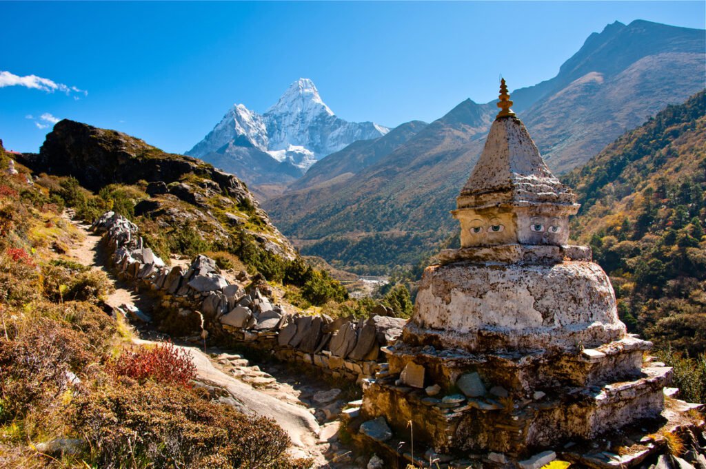
Sagarmatha National Park is home to the highest peak in the world Mt. Everest (8,848 m). The area was declared a national park in 1976. The park also has several other peaks. They are above 6,000 m. It was established as a World Heritage Site in 1979.
Most of the area of the park is above 3,000 meters. Sagarmatha is full of rugged terrain with deep gorges, glaciers and huge rocks. The Park boasts of a variety of wildlife and over 118 species of bird. While the forest is dominated by silver fir, birch, rhododendron and juniper trees, animals such as musk deer. The Himalayan tahr, the Ghoral, the serow, the wolf, and the Himalayan black bear may be spotted by trekkers in this region.
Endangered species may be seen by a lucky few visitors. It includes snow leopard, red panda, and two varieties of dazzling pheasants – the crimson-horned and The Himalayan monal (Lophophorus Impejanus) also known as the Impeyan, Nepal’s national bird. Smaller animals like marmots, pikas and martens are also found here.

The region ranges in altitude from less than 2,000 m above sea level at Jiri to the high peaks of the Himalaya at over 8,000 m. Hence the flora and fauna are diverse with a dense forest of pine, oak and the flowering rhododendrons up to 4,000 m.
Table of Contents
Establishment of Sagarmatha National Park
In 1973, the creation of Sagarmatha National Park was officially announced at WWF’s 3rd International Congress in Bonn, Germany. The park would conserve the Everest Ecosystem along with its endangered wildlife and rich Sherpa culture. Following this declaration, Sagarmatha National Park was established on 19 July 1976, covering an area of 1148 km2 in Solukhumbu district in the Eastern Development Region of Nepal. In recognition of its superlative natural phenomenon and unique culture, the park was inscribed in the World Heritage Site list in 1979. The Buffer Zone was declared on 1st January 2002 covering an area of 275 km2 including the settlements inside the park. On 23rd September 2007, Gokyo and associated lakes were designated as Wetlands of International Importance under Ramsar Convention.
Sagarmatha is a Nepali word derived from सगर Sagar meaning “sky” and माथा matha meaning “head”. Thus Sagarmatha means the forehead of the sky. This majestically scenic mountain park of snow-covered peaks, gorges and glaciers dominated by the highest mountain on Earth is geologically interesting and its wilderness values are outstanding. The Dudh Kosi valley is home to the unique culture of the Sherpas and is an ecological unit of biological, socio-economic and religious importance. Rare animals such as the snow leopard and red panda live in the Park.

In the Himalayan Mountains on the border with the Tibetan Autonomous Region of China, the Park lies in the upper catchment of the Dudh Kosi river, about 140 km east of Kathmandu and is centered on 27o57’55” N by 86o54’47” E. The Park is bordered to the east by Makalu Barun National Park, Rolwaling valley of Gaurishankar Conservation Area to the west, Qomolangma National Nature Preserve to the north and Sagarmatha National Park Buffer Zone to the south.
Physical Features
The Park’s core area covers the upper headwaters of the Bhote Kosi, Dudh Kosi and Imja Khola rivers which fan out under the crest of the Himalaya Mountains on the Tibetan border and meet near the area’s main settlement, Namche Bazar. The buffer area reaches down the Dudh Kosi valley to Lukla 18 km south of Namche. The Park is enclosed by high mountain ranges and lies over extremely rugged terrain, deeply incised valleys and glaciers culminating in Sagarmatha / Mt.Everest, the world’s highest mountain. The catchments are ringed by 25 or more peaks over 6,000m, and seven – Baruntse, Lhotse, Nuptse, Pumo Ri, Guachung Kang, Cho-Oyu, and Nangpai Gosum – over 7,000m high.
The rivers are fed by the long glaciers at the head of each valley: Nangpa Glacier on the Bhote Kosi, Ngozumpa Glacier on the Dudh Kosi, Khumbu Glacier on the Lobuje Khola and the Imja Glacier, one of eight which feed the Imja Khola under Sagarmatha. The Ngozumpa Glacier, 20 km long, is bordered on the west by the four Gokyo lakes impounded behind its lateral moraine. All the glaciers show signs of retreat and several glacial lakes have formed in recent decades; one, Imja Dzo which started to form in the 1970s, is now 1,200 ha in area and 45m deep. The upper valleys are U-shaped but below about 3,000m the rivers cut steep ravines through the sedimentary rocks and underlying granites. Near Namche Bazaar they join the Dudh Kosi which drains eventually into the Ganges. Except for some alluvial and colluvial deposits at lower levels, the soils are skeletal.
The best time to visit Sagarmatha National Park
The best time to visit the park is during the autumn months of October-November and from March-May in summer.
How to reach Sagarmatha National Park?
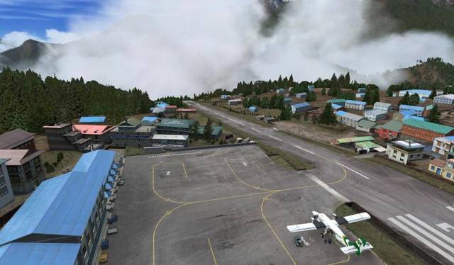
Namche is the only gateway to Sagarmatha National Park but Namche is very remote and difficult to reach. Namche is in the Khumbu region which has no roads. The most common way of getting to the park is to fly to Lukla from Kathmandu (25 min flight), and then trek onwards for 2 days.
How to reach Namche
Most travelers fly from Kathmandu to Lukla and trek to Namche Bazaar from there. However, some travelers directly reach Namche Bazaar by helicopter. And some choose by bus and then trek to Namche.
By Air and on Foot
Duration: 30-minute flight and 2 days of trekking
Most travelers get from Kathmandu to Lukla by plane, a journey of just 30 minutes. The Tenzing-Hillary Airport has a short, mountain-side runway. Delays, however, are very common due to weather conditions in Kathmandu, Lukla, or en route. It’s important to build some buffer days into your itinerary in the Everest region, so you don’t risk missing an important international connection if Lukla flights are grounded for a day or two. Helicopters are a handy back-up option if you had been booked to fly on a canceled or seriously delayed flight. They can fly in weather that airplanes can’t, so in an emergency could get you back to Kathmandu.
After arriving in Lukla, Namche Bazaar is still several hours’ walk away. While the walk can be done in one long day, it’s much more comfortable to spread it over two. Depending on the time you arrive in Lukla after your flight, there may not actually be time to walk all the way to Namche, even if you’re fit and raring to go. The trail is steadily uphill—even more so on the second day—and follows the Dudh Kosi River for much of the way. The first night of the EBC trek is often spent in Phakding.
On day two, the trek from Phakding to Namche Bazaar. It’s a steep trail so is quite a challenging day’s walk.
By Helicopter
Duration: 1 hour
If you’re not on a tight budget, traveling from Kathmandu to the Everest region by helicopter is an unforgettable experience. You’ll leave from the domestic terminal of Kathmandu’s Tribhuvan International Airport.
By Road and on Foot
Duration: 6-8 days
To avoid the flight to Lukla and enjoy more time trekking, it’s possible to take a Jeep to Jiri or Phaplu from Kathmandu (about a day’s journey), and then trek to Lukla and onwards to Namche Bazaar.
The trek from Jiri is known as the “Pioneers’ Route” because it’s how pioneering mountaineers used to reach the Khumbu region before the airport was built in Lukla in the 1960s. Nowadays this is an uncommon way of accessing the region, but the trails are uncrowded, with interesting cultures and beautiful views. The trek from Phaplu to Lukla takes three days, and Jiri to Lukla five, with another two days’ walk to Namche Bazaar.
Also Read World Heritage Sites
FACT SHEET |
|
| Location | Northern mountain of eastern Nepal |
| National Park Establishment | 19 July 1976 (04 Shrawan, 2033) |
| National Park Area | 1,148 Square Kilometers |
| IUCN Category | II |
| World Heritage Site Declaration | 1979 (UNESCO) |
| Buffer Zone Declaration | 01 January 2002 (17 Poush, 2058) |
| Buffer Zone Area | 275 Square Kilometers |
| Buffer Zone Households | 1,619 |
| Buffer Zone Population | 7,745 |
| Major Ethnic Group | Sherpa |
| Major Religion | Buddhism |
| Major Glaciers | Khumbu, Imja, Ngozumpa and Nangpa |
| Ramsar Site | Gokyo and the associated wetlands |
| Major Rivers | Dudh Koshi, Bhotekoshi and ImjaKhola |
| Major Peaks | Sagarmatha (8,848 m), Lhotse (8,501 m), Cho Oyu (8,153 m) and Nuptse (7,896 m) |
| Bioclimatic Zone | Lower Temperate, Upper Temperate, Sub-alpine, Alpine and Nival |
| Climate | Temperate to the Arctic |
| Main Mammals | Snow Leopard, Musk Deer and Red Panda |
| Major Trees | Pine, Hemlock, Fir, Juniper and Birch |
| Annual Visitors | 45,112 in the Fiscal Year 2016-2017 (Foreign Tourists Only) |
| Annual Revenue | Rs. 14,39,56,605 (US $ Equivalent 1411340) in the Fiscal Year 2016-2017 |


 world's Heighest peak, pine, oak, rhododendrons)